Strategy ONE
Badge Location Hierarchy

In MicroStrategy Badge the Longitude and Latitude are logged for all transactions on Badge app. The location setting can be managed from Network Manager and the personal device of the user.
In order to provide additional level on analysis, Platform Analytics uses a Google® API call to populate the Address, City, State and Country associated with each set of lat/long coordinates. By default, you are subject to the limits of the Google® Geocoding API free license, this is noted as a prerequisite in the Platform Analytics. For more prerequisites, see Platform Analytics Prerequisites. If the API limit has been reached, the address, city, state, and country will be recorded as Unknown. However, the latitude and longitude will always be recorded if sent from a mobile device. If the location is restricted by the device, the longitude/latitude values will be null and the location tables will be populated with Location Services Disabled.
The rows in the tables are the exact values provided by Google. In some cases, Google will change the value returned in the API of the address/city/state/country and a new record will be added to the table. For example, Colorado and CO.
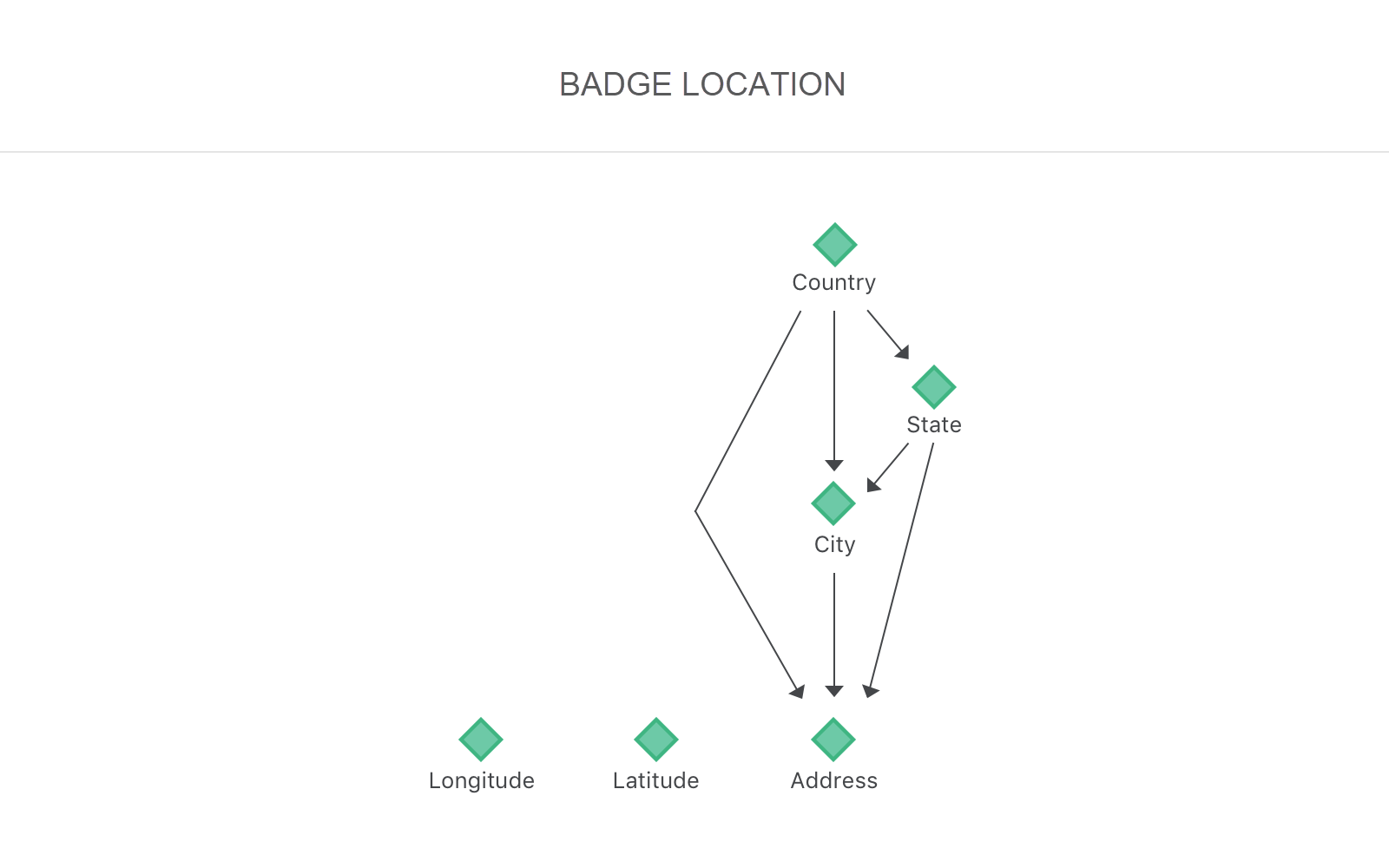
In the Location hierarchy, the Address attribute is the direct child of City, State and Country attributes. This will help reduce the in-memory joins between the attributes to improve the performance of reports and dashboards related to the Location Hierarchy.
To use location-based analysis in Platform Analytics, by default, you are subject to the limits of the Google® Geocoding API free license. For heavier use of location-based features, purchase a Google Maps API for Work license. For information on the Google Maps API, see Google Maps Platform.
lu_country
The list of countries returned by the Google® API from a corresponding latitude/longitude transaction by the user.
|
Column |
Description |
Data-Type |
|---|---|---|
|
country_id |
The auto-generated numeric ID of the Country. |
bigint(20) |
|
country_desc |
The name of the country returned from the Google® API. Example elements include, Unknown Location Services Disabled United States Germany China |
varchar(255) |
lu_state
The list of states returned by the Google® API for which there has been a corresponding latitude/longitude transaction by the user. Not all longitude and latitude coordinates are associated with a State. In these cases, the row will be populated with No State (<name of the country>).
|
Column |
Description |
Data-Type |
|---|---|---|
| state_id | The auto-generated numeric ID of the state. | bigint(20) |
|
state_desc |
The name of the state returned from the Google® API. Example elements include, Unknown Location Services Disabled No State(Germany) Virginia |
varchar(255) |
|
country_id |
The numeric ID value for the corresponding country to each state. |
bigint(20) |
lu_city
The list of cities returned by the Google® API for which there has been a corresponding latitude/longitude transaction by the user. Not all longitude and latitude coordinates are associated with a city. In these cases, the row will be populated with Unknown (<name of the state>).
|
Column |
Description |
Data-Type |
|---|---|---|
|
city_id |
The auto-generated numeric ID of the city. |
bigint(20) |
|
city_desc |
The name of the state returned from the Google® API. Example elements include, Unknown Location Services Disabled Unknown (Virginia) Tysons Corner |
varchar(255) |
|
state_id |
The numeric ID for the corresponding state to each city. |
bigint(20) |
|
country_id |
The numeric ID for the corresponding country to each city. |
bigint(20) |
lu_address
The list of Address returned by the Google® API from a corresponding latitude/longitude transaction by the user. Not all longitude and latitude coordinates are associated with an address. In these cases, the row will be populated with Unknown (<name of the state>).
|
Column |
Description |
Data-Type |
|---|---|---|
|
address_id |
The auto-generated numeric ID of the address. |
bigint(20) |
|
latitude |
The latitude coordinate associated with the address. |
double |
|
longitude |
The longitude coordinate associated with the address. |
double |
|
street_address |
The street address returned from the Google® API. Example elements include, Unknown Location Services Disabled 1850 Towers Cres Plaza, Tysons, VA 22182, USA |
varchar(255) |
|
city_id |
The numeric ID for the corresponding city to each address. |
bigint(20) |
|
state_id |
The numeric ID for the corresponding state to each address. |
bigint(20) |
|
country_id |
The numeric ID for the corresponding country to each address. |
bigint(20) |
